Archive 19/01/2023.

Urho3 Geomapping

vivienneanthony

Hi

how does Urho geomapping and terrain work? Does it take a RGB like .1,.1,.1 as the height value or something Red as height then maybe Blue or Green as something more finite value.

Vivienne

Or can I modify the height map function to maybe use r as height then blue.as normal.

vivienneanthony

If I think about it if the range of array is 0 to 1 convert it to 256*256 possibities with i use two channels. color * 8192 So, Red would be (color/256) that would produce the first value then reminder would be the Green channel. Hmmm.

I tried this but its not working. If I read your message correctly.

[code]/// generate perlin output
bool Procedural::GenerateBuild(float * inputData1, unsigned * output)
{
/// loop through all the floats then convert to grayscale setting the color basis to .5 (forcing values 0 to 1)
for(unsigned x = 0; x<width_; x++)
{
for(unsigned y = 0; y<height_; y++)
{

        /// incremennt memory which seems to work
        int index = x+(y*height_);

        unsigned int color = inputData1[index]*8192;

        /// If elevation is over .5
        unsigned int heightscale=color/256;
        unsigned int heightprecision=color%256;

         /// test
        unsigned colr = heightscale;
        unsigned colg = heightprecision;
        unsigned colb = 0;

        unsigned int col = rgba32ToUInt(colr,colg,colb, 255);
        output[index] = col;      /// set grayscale - rgba is not needed. it seems to be screwy with this type of code.
    }
}

return true;

}
[/code]

vivienneanthony

The first idea did not work so I basically wiped it out.

I thought maybe I can scale the float 0 to 1 the heightmap to 0 to 255. Basically muiltplying that with the col. I thought leaves me with a reminder that can be the precision.

For example, scaled at one point is value 128 but there is a reminder of .124 which I think would be the precision. I simply muiltplied that by 255. Creating the second value the Green in the channels.

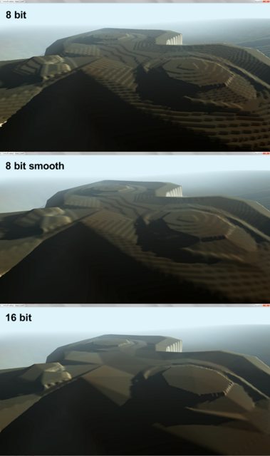
The result looked smooth when I used the method without the minecraft looking stuff. I am leaving the code here maybe you have a better idea.

/// generate perlin output
bool Procedural::GenerateBuild(float * inputData1, unsigned * output)
{
    /// loop through all the floats then convert to grayscale setting the color basis to .5 (forcing values 0 to 1)
    for(unsigned x = 0; x<width_; x++)
    {
        for(unsigned y = 0; y<height_; y++)
        {

            /// incremennt memory which seems to work
            int index = x+(y*height_);

            unsigned col = inputData1[index]* 255;  /// create color value

            float precision = ((float)inputData1[index]* 255)-col;

            col = rgba32ToUInt(col,precision*255, 0, 255);

            output[index] = col;      /// set grayscale - rgba is not needed. it seems to be screwy with this type of code.
        }
    }

    return true;
}

Sorry. It’s late my time. It’s the only thing I can think off.

TikariSakari

Thank you for the code. I might need something like this at some point, if I need to generate random battle maps. I was also considering of using the terrain with procedural map generation, so this will potentially save me a bit of time in the future.

This is not something that actually matters, but still good thing to know/do. You should probably have the for loops x and y the opposite way to avoid possible cache misses when indexing the array.

So instead of:

    for(unsigned x = 0; x<width_; x++)
    {
        for(unsigned y = 0; y<height_; y++)
        {

            /// incremennt memory which seems to work
            int index = x+(y*height_);

            unsigned col = inputData1[index]* 255;  /// create color value

swapping x and y around

    for(unsigned y = 0; y<height_; y++)
    {
        for(unsigned x = 0; x<width_; x++)
        {

            /// incremennt memory which seems to work
            int index = x+(y*height_);

            unsigned col = inputData1[index]* 255;  /// create color value

But since you are most likely only building this once and if the width/height isn’t a huge number there is a possibility that not that many misses even happen or even if they do, it might not matter.

Bananaft

Can you please name some? If I’ll get 16bit heightmap TIFFs, what is the best way to split em on two channels?

vivienneanthony

No problem.

The code I modified to account for y scale.

The thing about the code its part of several procedual generation class and components not in the native code. Its something I put together.

It needs to be faster in general and unload the computation on a GPU. I want the base computation to less then a second.

I welcome anyone who want to assist getting the code more feature rich, faster, and preppef to be added

Vivienne

[quote=“TikariSakari”]Thank you for the code. I might need something like this at some point, if I need to generate random battle maps. I was also considering of using the terrain with procedural map generation, so this will potentially save me a bit of time in the future.

This is not something that actually matters, but still good thing to know/do. You should probably have the for loops x and y the opposite way to avoid possible cache misses when indexing the array.

So instead of:

    for(unsigned x = 0; x<width_; x++)
    {
        for(unsigned y = 0; y<height_; y++)
        {

            /// incremennt memory which seems to work
            int index = x+(y*height_);

            unsigned col = inputData1[index]* 255;  /// create color value

swapping x and y around

    for(unsigned y = 0; y<height_; y++)
    {
        for(unsigned x = 0; x<width_; x++)
        {

            /// incremennt memory which seems to work
            int index = x+(y*height_);

            unsigned col = inputData1[index]* 255;  /// create color value

But since you are most likely only building this once and if the width/height isn’t a huge number there is a possibility that not that many misses even happen or even if they do, it might not matter.[/quote]

Bananaft

Thank you for reply.

From this thread I’ve just found out about two channel system, and want to know how to use it, given, I have some 16bit heightmap. Let’s say, I can output any format, tiff, raw, whatever. I need a way to process them into R+G image, that Urho3d can read (PNG or such).

I’ve checked free version of L3DT, and didn’t found two channel R+G output.

If your java thingy may help me with that, then I sure want to check it.

Bananaft

[quote=“Sinoid”]
I’ll write a TIFF converter. Will take a day or two.[/quote]

Whoa! ok, cool. Can’t wait to try.

I also found out, that PNG has 16bit support, but Urho3d crashes trying to load it.

TikariSakari

I tried using 8bit monochrome pngs, but I think it treats them differently somehow, altho it did work for the heightmap. The picture did work though, but maybe it counts 2 pixels in a row for one 16bit data.

Bananaft

[quote=“Sinoid”]
I might be almost done with this packer but I could use more test files that came from different programs. Can you toss up a TIFF file of yours onto dropbox or someplace and PM me a link, tell me where the TIFF came from, and even better if you’ve got some screenshots (like from inside the tool the tiff was generated from, for height/feature-point reference)?[/quote]

Just PM’d you two test images.

friesencr

For nix users just use image magick

sudo apt-get install imagemagick
convert input.tiff output.png

Bananaft

Hey, Sinoid.

I finally got my hands on your Tiff packer.

Thank you very much for this awesome tool!